Unmanned aerial vehicles (drones)
The use of unmanned aerial vehicles (UAVs) in Lithuania is growing rapidly, so it is particularly important to ensure that these flights are carried out safely and in compliance with applicable regulations. Oro navigacija manages the airspace designated for drones, provides up-to-date information about applicable restrictions and ensures coordination of flights with air traffic services.
 |
 |
| App for IOS | App for Android |
[[#ex]]
UAVs traffic management system utm.ans.lt
The unmanned aerial vehicle traffic management system utm.ans.lt is a digital platform designed to plan, register, coordinate and manage drone flights in very low airspace. It helps ensure that flights are conducted safely and according to regulations.
Using the system, you can:
- see the geographic zones crossed during the planned flight,
- find out whether a permit is required in a specific area,
- submit flight plans and applications directly to authorities,
- ensure transparent cooperation with responsible services.
Currently, the UTM system applies only to airspace areas where additional permits are not needed — mostly uncontrolled airspace and CTR zones up to specified altitudes. In such areas, operators can plan and declare their flights directly in the system in compliance with EU and national legal requirements.
If a planned flight is within prohibited zones or over military areas, the usual permit procedures apply — applications must be submitted in advance within the established time limits
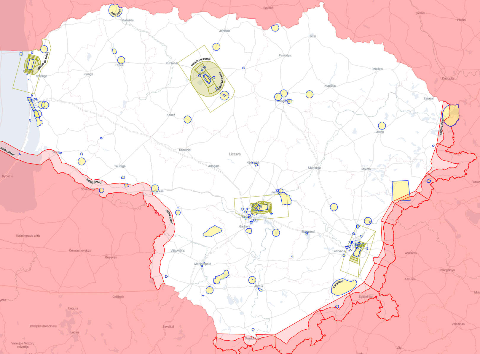
Geographical Zones for Drones
What is a geographical zone and what types are there?
Geographical zones for unmanned aircraft (geozones) are specific segments of Lithuanian airspace where special restrictions or requirements are established in order to ensure the safety and security of civil aviation, military and strategic objects, as well as the public and privacy.
Types of geozones according to EU regulations and the Law on Aviation of the Republic of Lithuania
Prohibited zones – a geographical zone in which all UAS flights are prohibited, except in cases where the manager of the geographical zone grants permission in accordance with their established procedures.
Restricted zones – a geographical zone where restrictions are introduced related to administrative procedures, operational limitations, technical UAS requirements, or mandatory UAS functions (such as flight altitude, UAS weight, or UAS aircraft class).
Special operations zones – a geographical zone in which one or more requirements of the open category may not apply.
U-Space – a geographical zone in which flights are conducted in accordance with the requirements established in European Commission Regulation (EU) 2021/664.
No airspace risk assessment is required to establish prohibited and restricted geographical zones. An airspace risk assessment carried out by the Transport Competence Agency is required to establish special operations and U-Space zones.
Who can establish geographical zones and on what basis?
The Lithuanian Transport Safety Administration (LTSA) is responsible for establishing geographical zones for unmanned aircraft systems (UAS), in accordance with Article 18(5) of the Law on Aviation of the Republic of Lithuania.
Geographical zones over military territories and within a radius of up to 2 km around these territories, as determined by the Minister of National Defence, as well as in the border zone, are established by the Commander of the Armed Forces, in coordination with the LTSA, in accordance with procedures set by the Commander.
Institutions of the national defence system, intelligence institutions, the State Protection Service, and statutory institutions have the right to establish temporary prohibited or restricted geographical zones for unmanned aircraft systems (UAS).
How can you find out where geozones are located?
All geozones approved by the Lithuanian Transport Safety Administration and the Commander of the Armed Forces are published on the UTM platform.
Prohibited zones
Prohibited zones are areas of airspace in which UAS (drone) flights are strictly prohibited, except in cases where a special permit has been obtained from the responsible authority.
These zones are established to ensure state and public security, protect military infrastructure, strategic objects (such as infrastructure or energy facilities), other sensitive sites, and to ensure aviation safety in the vicinity of aerodromes of particular importance.
Possible designations: UP, T, EYP, BRDR
Important information for UAS operators:
- Flights without a permit are prohibited, regardless of the type of UAV or flight altitude.
- The issuance of a permit is exceptional and assessed on a case-by-case basis.
- Violations may result in criminal or administrative liability.
For example, geozones may include military bases or other military facilities, nuclear and strategic infrastructure objects, the Presidential Palace, the Seimas (Parliament) and other state-protected sites of national importance, as well as border areas along the state border of the Republic of Lithuania, where UAS flights are prohibited for reasons of national security.
Restricted zones
Restricted zones are areas of airspace where unmanned aircraft (UAS) flights are permitted, but additional restrictions apply. In such zones, limitations on flight altitude or operating times are often established, and in some cases the use of specific technological solutions may be required.
Temporary air navigation notices (NOTAMs) may also be issued, temporarily restricting or modifying the conditions in force within a specific zone. In certain zones, remote identification (Remote ID) or other identification solutions may be required.
These zones are designated as:
URVI – Vilnius CTR, URKA – Kaunas CTR, URSA – Šiauliai CTR, URPA – Palanga CTR.
Important information for UAS operators
It is particularly important for UAS operators to check the UTM system before each flight to determine whether restrictions apply at the planned location. Depending on the type of zone and its period of activity, a special permit may be required. In addition, it is essential to ensure that both the UAS and the operator comply with all applicable technical and safety requirements.
Restricted zones may include a variety of objects and areas, such as city centers or residential areas, zones around strategic facilities (e.g. water supply facilities, bridges, or transport hubs), as well as temporary locations where events or protests are taking place. Restricted zones also include controlled airspace around controlled aerodromes (airports), where air traffic is coordinated by air traffic control (ATC) services.
Other zones
Danger Area
Danger areas are portions of airspace where activities may take place that pose a hazard to unmanned aircraft (UAS) flights, such as military exercises, firing ranges, explosions, experimental testing, or other high-risk activities.
Possible designation: EYD
Temporary segregated area (TSA)
A Temporary Segregated Area (TSA) is a temporary special-use airspace established for a specific period and purpose (e.g. exercises, special flights, or testing). When an EYTSA is activated, the airspace is reserved exclusively for the designated user, and all other traffic (including drones) is prohibited from operating within it.
When the area is not active, it does not exist as segregated airspace, and flights may be conducted in accordance with the general rules.
Possible designation: EYTSA
Drone flights in controlled airspace
To conduct an unmanned aircraft (UA) flight above the defined vertical limits of geographical zones within an aerodrome traffic control zone, it is first necessary to hold a remote pilot STS certificate issued by the Transport Competence Agency, and, where applicable, an authorization to conduct operations in the specific category. Flights over the airports of Vilnius, Kaunas, and Palanga (Zone 0) require permission from the aerodrome operator, which is issued via the UTM system. Flights within the zero zone of Šiauliai Airport additionally require permission from both the aerodrome operator and the Commander of the Lithuanian Air Force Air Base, which must be obtained separately and submitted by email to bepiločiai@ans.lt. Without these documents, flights in this airspace are prohibited.
All flight applications must be submitted via the UTM system (website utm.ans.lt or the mobile application Lithuania Drone Map). When planning a flight in controlled airspace above the defined vertical limits of UAS geographical zones, the application must be submitted no later than the last working day before the flight by 12:00 local time. Applications submitted late are not approved. The application must include the contact details of the remote pilot, two mobile phone numbers*, the planned flight time, location, and altitude. If flights are planned for multiple days, a separate application must be submitted for each day.
A submitted flight application in the UTM system is coordinated electronically; however, its approval does not constitute authorization to fly.
On the day of the flight, the pilot must, no later than 30 minutes before the flight, submit a request for take off in the UTM system (by pressing the “Request Take off ” button) and inform the air traffic control center by phone of the intention to conduct the flight. The contact details of the air traffic control center will be sent to the applicant via a message in the UTM system or to the provided email address. The flight may only be conducted after receiving final clearance from the air traffic control center. Throughout the entire flight, the pilot must maintain communication with the air traffic control center and comply with all its instructions. Upon instruction, the flight must be immediately adjusted or terminated.
After completing the flight, no later than within 5 minutes, the pilot must mark the end of the flight in the UTM system (by pressing “End Flight”) and inform the air traffic control center by phone.
Flights may be restricted or prohibited depending on air traffic intensity or meteorological conditions.
*According to the applicable procedure, the remote pilot must provide two phone numbers that can be used to establish contact in unforeseen situations. The second phone number should be written next to the first with a space in between. No other characters (such as commas, periods, or dashes) should be used.
Useful links
- Geozones – European geographical zones for unmanned aircraft operations
- VFR Aeronautical Chart (Online)
- Lithuanian Unmanned Aircraft Vehicle Traffic System
- NOTAM (Notice to Airmen)
- Lithuanian Transport Safety Administration (Unmanned Aircraft)
- Transport Competence Agency (Unmanned Aircraft)
FAQ
- Where can I find the Lithuanian drone map?
You can find the Lithuanian drone map by entering the website address into your browser (utm.ans.lt). The map is available as an app for Android and IOS users. In the Google Play or the App store, type in the name Lithuania Drone Map and you will find the application released by Oro Navigacija. You can also scan the QR code below.
|
|
| App for IOS | App for Android |
- What is a Prohibited Area (P)?
An area where drone flying is strictly prohibited, such as military areas or strategic objects.
Tip: You cannot fly a drone without special permission. Information about zones and take-off conditions can be found on the utm.ans.lt drone map or in the Lithuania Drone Map mobile app.
- What is a Restricted Area (R)?
An area where flying is allowed, but with certain restrictions, such as limited height, a certain distance from objects, or permission from a responsible authority.
Check the utm.ans.lt before you go.
- Is it possible to fly at the airport with only an A1/A3 license?
No. Even with an A1/A3 license, it is prohibited to fly in the zero (CTR) zone. An STS license and permissions from the Airport and Oro Navigacija are required.
- How do I find out if flying is allowed in a certain location?
Check out utm.ans.lt or Lithuania Drone Map app, where prohibited, restricted and temporarily restricted zones are visible.
- Does the A1/A3 license allow you to fly in prohibited area?
No. In prohibited and restricted zones, permits from the relevant authorities are required, and a certificate is required.
- What is a Temporary Restricted Area?
An area where flights are restricted for a limited time, for example due to events, VIP flights or air shows.
Check utm.ans.lt – zones may only be active for a certain time and at certain altitudes.
- Can I fly drone near people or buildings?
In the A1/A3 category, you may fly over people only with very light drones (<250 g). Larger drones are not allowed to fly over groups of people or buildings without permission.
- How to find out the height of prohibited and restricted zones?
The map utm.ans.lt and the Lithuania Drone Map app indicate vertical limits – the height up to which you can fly without additional permits.
- Do I need to check the zones everytime before I fly?
Yes. Prohibited, restricted and temporarily restricted zones may change, so it is necessary to check utm.ans.lt or the Lithuania Drone Map app each time.
- If I fly a drone in a restricted area, can anyone punish me?
The Public Security Service (PSS) is responsible for UAV in the restricted area and may conduct inspections and apply administrative measures.
- What are the penalties for flying a drone in a prohibited area?
Administrative penalties may apply, including fines or confiscation of the drone. The amount of the fine depends on the nature of the violation and the category of the drone.
Tip: always check utm.ans.lt or Lithuania Drone Map app before flying to avoid any inconvenience.
- How can I get permission to fly in a prohibited or restricted area?
To fly in a prohibited or restricted area, permission must be obtained from the relevant authorities.
- More information and links to application forms can be found at utm.ans.lt.
- In the future, it will be possible to obtain permits directly through utm.ans.lt, without additional paper documents or separate electronic forms.
Tip: always plan ahead and check if the area is temporarily restricted, as a permit may be required even in temporarily restricted areas.
- I plan to fly above 120 m from the nearest point on the ground, what permission do I need to obtain?
To exceed the maximum limits, you must obtain permission from the Transport Competence Agency (TKA). TKA contact information – uas@tka.lt.
- I'm not sure if I can fly or not – what should I do?
- Check the UAV map at utm.ans.lt or in the Lithuania Drone Map mobile app.
- If it is still unclear, check the official aviation information: www.ans.lt, section "Unmanned aerial vehicles".
- If you don't receive a clear answer, write to bepilociai@ans.lt – the responsible specialists will advise and explain whether the flight is allowed.
Tip: never move until you are sure of the status of the zone – this will protect you from violations and penalties.
Contact for drone questions
For questions regarding unmanned aerial vehicles, please write to bepilociai@ans.lt 24/7, or call +370 706 94 537 during business hours (from 7:30 AM to 4:15 PM, on Fridays until 3:00 PM, on pre-holiday days until 3:15 PM).
[[#ex]]
[[#ex]]